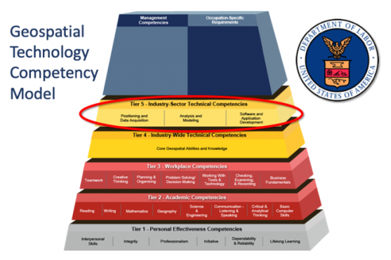
You may come into this course with a general knowledge of and experience with the many applications of GIS, but do you know what it takes to be a GIS professional in this rapidly-changing field? In Geog 482, we use case studies of meaningful applications of GIS to introduce topics within the major industry sectors defined by the U.S. Department of Labor's Geospatial Technology Competency Model (GTCM): Positioning and Data Acquisition, Analysis and Modeling, and Software and App Development. You will develop the ability to use maps and geospatial technology as a story-telling medium, and you will be able to demonstrate how and why GIS matters.
At a Glance
Details
| Credits |
3.00
|
|---|---|
| Topics |
Applications in GIS
Fundamentals of GIS and Mapmaking
Geospatial Programming and Software Development
|
| Technologies |
ArcGIS Online
ArcGIS Pro
ArcGIS Story Maps
|
| Syllabus | GEOG 482 Sample Syllabus |
Upcoming Offerings
| Semester | Instructor |
|---|---|
| Summer 2026 | Amy Avery, M.A. |
| Fall 1, 2026 | Adrienne Goldsberry, M.A. |
| Fall 2, 2026 | Adrienne Goldsberry, M.A. |
| Spring 1, 2027 | Amy Avery, M.A. |
| Spring 2, 2027 | |
| Summer 2027 | Amy Avery, M.A. |
Meet Our Faculty Instructors
What Our Students Say
Exceeded my Expectations.
“GEOG 482 certainly exceeded my expectations. Not only was it taught by a leading GIS authority, it was very well organized, highly engaging with strong course content, and did not seem like 'distance learning.'”
— Eric Elms
Fun, innovative, introductory course to GIS!
“GEOG 482, Making Maps that Matter with GIS is a fun, innovative, introductory course to GIS! It helps you learn a wide array of subjects and issues by allowing you to focus your studies on topics that are of interest to you.”
— Mark