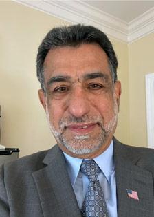
I am Vice President and Chief Scientist for Woolpert, Inc., where I am responsible for designing and managing strategic programs to develop and implement new remote sensing technologies.

Contact Qassim
Qassim Abdullah is an accomplished scientist with more than 40 years of combined industrial, research and development, and academic experience in analytical photogrammetry, digital remote sensing, and civil and surveying engineering. Currently, Qassim is a lead research scientist and a member of the Woolpert Labs team. His latest accomplishments include evaluating and introducing the Geiger and single photon LiDAR to the geospatial industry and leading Woolpert research activities in the field of Unmanned Aerial System (UAS), its sensor calibration, and its workflow development. Qassim publishes a monthly column “Mapping Matters,” in the American Society for Photogrammetry and Remote Sensing (ASPRS) journal PE&RS and he is the recipient of the 2010 Photogrammetric Fairchild award of the ASPRS. Qassim serves as an adjunct professor at the University of Maryland, Baltimore County, and at Penn State, teaching graduate courses on UAS, Photogrammetry and Remote Sensing. Most recently, Qassim was awarded the Presidential Citation award from the ASPRS in recognition of his contributions in co-authoring the new Positional Accuracy Standards for Digital Geospatial Data. Qassim is a licensed professional surveyor and mapper with the states of Florida, Oregon, Virginia, and South Carolina. He is also a certified thermographer by the FLIR Infrared Training Center and a Certified GEOINT Professional in Remote Sensing and Imagery Analysis (CGP-R) by the United States Geospatial Intelligence Foundation (USGIF).